
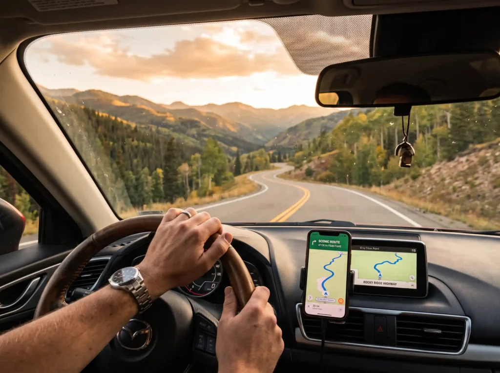
Some trips start with a spreadsheet. A road trip starts with a tank of fuel and a rough idea of where you want to end up.
That gap between structure and spontaneity is what makes self-drive travel unlike anything else. You control the pace, you choose when to stop, and the route itself becomes part of the experience. Six of the world’s most celebrated drives capture that feeling at its best — each one distinct, each one genuinely worth the journey.
What follows is the ground-level picture of all six: what to expect, which stops deserve the time, and how many days each actually needs.
The World’s 6 Best Road Trips: Routes and What to Expect
Route 66, USA — America’s Most Legendary Road Trip
Route 66 runs 3,940 kilometres (2,448 miles) from Chicago, Illinois, to the Santa Monica Pier in California. That crossing takes you through eight states and three time zones. The road was officially decommissioned in 1985 and replaced by Interstate highways. To follow the historic alignment, you need to look for Historic Route 66 signs. Standard GPS navigation won’t do it, and most apps won’t either.
The drive is as much about American cultural history as it is about landscape. Just outside Amarillo, Texas, Cadillac Ranch is one of the most-photographed roadside stops in the country. Ten Cadillacs buried nose-first in a field, covered in spray paint. The Arizona stretch through Seligman and Oatman still feels preserved from the 1950s, and the neon-lit diners and roadside motels along the route are genuinely worth stopping for — not just photographing.
Budget two to three weeks. Anyone who tries to rush this in under ten days typically spends most of it on the Interstate, which defeats the purpose entirely. The Grand Canyon sits close enough to the route in northern Arizona that skipping it would be a genuine mistake.
Iceland’s Ring Road — Volcanoes, Glaciers, and Waterfalls in One Circuit
Iceland’s Ring Road, officially Route 1, circles the entire island in 1,332 kilometres. It covers almost every landscape type Iceland has to offer: lava fields, black sand beaches, active volcanic zones, towering waterfalls, and glacier lagoons. These are the kinds of scenes that appear regularly in nature documentaries. They’re just lining the road.
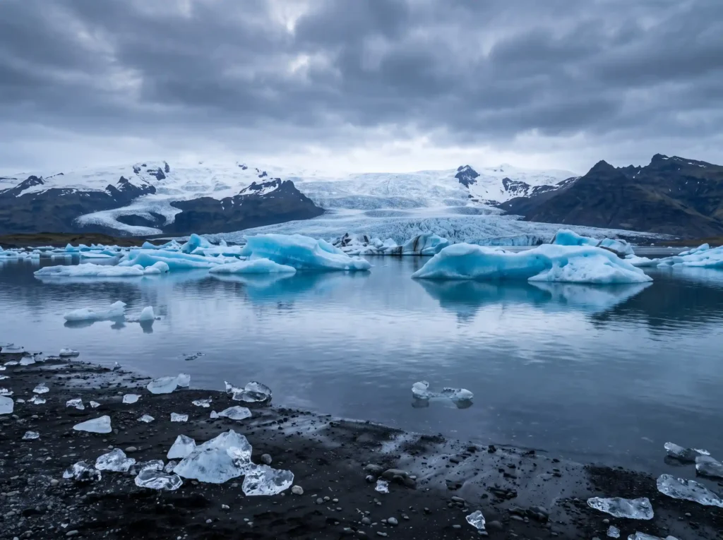
The south coast holds the most iconic stops. Seljalandsfoss is a waterfall you can walk behind — a narrow path through the spray that is cold, wet, and worth every step. Skógafoss, a few kilometres further east, drops 60 metres straight down and rewards early risers with a rainbow in the mist on sunny mornings. Jökulsárlón glacier lagoon sits at the edge of Vatnajökull, Europe’s largest glacier, and the floating icebergs there are a shade of blue that photographs struggle to capture accurately. The north centers on the Mývatn area: mud pools, lava formations, and geothermal steam vents all within a short drive of each other.
Plan for 10 to 14 days. The Ring Road itself is fully paved, so a standard rental car covers it without issue. A 4×4 becomes essential the moment you want to explore the F-roads that branch into the interior highlands. Rental companies prohibit standard vehicles on F-roads for good reason: these are unpaved mountain tracks that can become impassable without warning. If your itinerary might include any interior routes, book a 4×4 from the start.
One thing most first-time Iceland drivers underestimate: the weather can change completely in under an hour. Check the Icelandic Road and Coastal Administration (road.is) and the Icelandic Met Office (vedur.is) before each morning’s drive. Both update road and weather conditions in real time.
The Garden Route, South Africa — Coastline, Forests, and Wildlife in One Drive
The official Garden Route covers 300 kilometres between Mossel Bay and Tsitsikamma National Park. In practice, most travelers start in Cape Town and drive the N2 highway through to the Addo Elephant National Park, a total of around 750 kilometres. That extended version gives the route its real range and variety.
Hermanus, roughly 120 kilometres east of Cape Town, is consistently rated among the world’s best destinations for land-based whale watching. Southern right whales arrive between July and December and come close enough to shore that binoculars are optional. The Robberg Peninsula near Plettenberg Bay is one of the finest short hikes on the route. It’s a three-to-four hour loop with ocean views on both sides and a large Cape fur seal colony at the western tip. The suspension bridges over the Storms River gorge in Tsitsikamma National Park are genuinely impressive, though the area gets busy in peak season.
The Addo Elephant National Park at the eastern end is malaria-free, which matters for families or anyone with medical restrictions. Budget 10 to 14 days for the full extended route. South Africa drives on the left. If you’re used to driving on the right, take it slowly through intersections and roundabouts for the first day or two.
Great Ocean Road, Australia — Limestone Cliffs, Rainforest, and Wild Koalas
The Great Ocean Road runs 243 kilometres along the Victorian coastline between Torquay and Allansford. Built between 1919 and 1932 by returned soldiers, the road is dedicated as a war memorial. Most visitors don’t know this, and it gives the drive a weight that goes beyond the scenery.
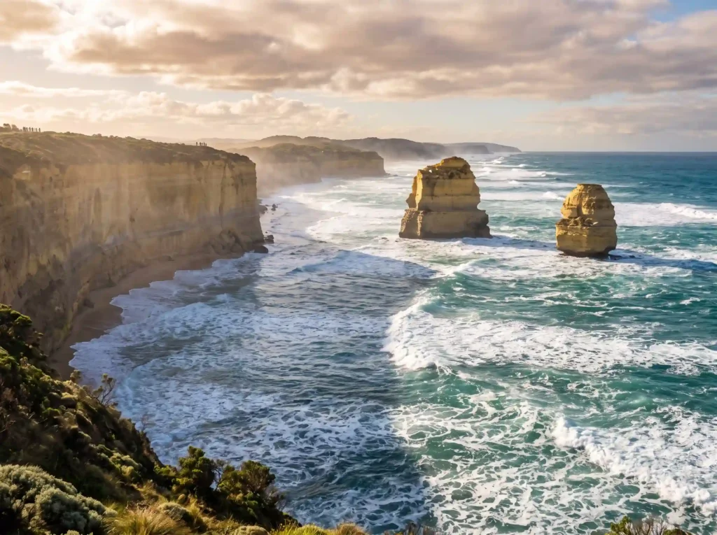
The Twelve Apostles are the route’s most photographed attraction. Here’s what most guides leave out: only eight of the original twelve limestone stacks are still standing. The others have collapsed into the Southern Ocean over time, and more will eventually follow. Knowing they’re temporary makes the visit feel more worthwhile, not less. The Loch Ard Gorge nearby is equally dramatic and far less crowded, especially in the morning.
Kennett River, roughly two-thirds of the way along the route, is one of the most reliable places in Australia to spot wild koalas. The grey gum trees along Grey River Road hold dozens of them, and they tend to be active in the early morning and late afternoon. The Great Otway National Park runs through the middle of the route. Its lush temperate rainforest feels completely different from the clifftop sections, and is worth stopping for.
Drive east to west, Torquay toward Allansford, for the best views. The cliff formations sit on your ocean side, which in Australia is your driver’s side. Plan three to five days.
The Wild Atlantic Way, Ireland — Europe’s Longest Coastal Route
At 2,500 kilometres, the Wild Atlantic Way is one of the longest defined coastal driving routes in the world. It runs the full length of Ireland’s western coast from Malin Head in County Donegal to Kinsale in County Cork. You don’t need to drive all of it in one go. The route breaks into sections, each of which works as a standalone itinerary.
The Cliffs of Moher in County Clare are the route’s most visited attraction. The reputation is justified, though the cliffs get crowded from late morning through mid-afternoon. Arriving early makes a real difference. The Slieve League cliffs in Donegal are actually taller than the Cliffs of Moher and see a fraction of the visitors. One of the better-kept secrets on an otherwise busy route. The Dingle Peninsula in Kerry runs as a circular loop combining coastal scenery with ancient archaeology. Beehive huts dating back 1,500 years sit in open fields overlooking the Atlantic.
Budget at least two to three weeks for the full route. The roads along Ireland’s west coast are genuinely narrow. Some sections barely fit two cars side by side, and a smaller rental car makes a real difference. Evenings in the coastal villages tend to follow the same pattern: a pub, a fire, live traditional music. It was all there long before it became a tourist attraction.
The Icefields Parkway, Canada — 232 Kilometres Through the Heart of the Rockies
The Icefields Parkway, officially designated Highway 93 North, connects Banff and Jasper National Parks in Alberta across 232 kilometres. The scenery alongside is snow-capped peaks, dense conifer forest, and glacial lakes in shades of turquoise that look digitally enhanced in photographs — except they’re not. The colour comes from glacial rock flour suspended in the water, which refracts light differently from a conventional lake.
Peyto Lake has the most distinctive shape: viewed from the lookout, it resembles a wolf’s head. Get there before 9 a.m. — that’s when the tour buses start arriving in volume. Bow Lake is quieter and has its own kind of austere beauty. The Columbia Icefield is the largest accessible icefield in the Rocky Mountains. The Athabasca Glacier, one of its main outlets, can be walked on during guided tours. The ice is retreating visibly year on year. It’s the kind of place that makes an impression whether or not you care about glaciology.
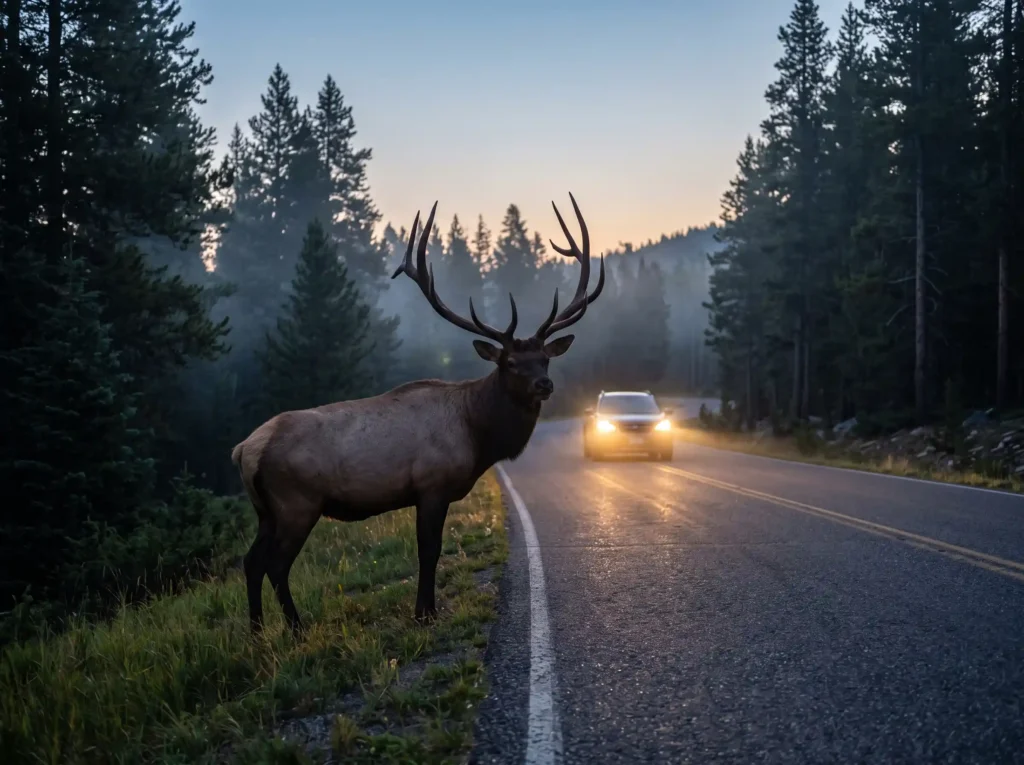
The pure driving time is around three hours. Give it at least one full day, and ideally two. One practical detail most guides don’t mention: there is one fuel station along the entire 232-kilometre route, at Saskatchewan River Crossing, and it’s priced accordingly. Fill up in Banff or Lake Louise before you leave. Mobile signal is largely absent across the whole stretch, so download offline maps before departure and carry a physical backup. Wildlife — bears, elk, and bighorn sheep — appears on and beside the road regularly. Keep speed low and distance large.
Practical Challenges to Know Before You Go
Every route on this list is manageable with preparation. The problems that derail road trips usually come from the same handful of sources, and most of them are avoidable.
- Driving on the left: Australia, South Africa, and Ireland all drive on the left. The first day requires real concentration, particularly at intersections and roundabouts. Give yourself a slow start on day one. Don’t begin your trip at rush hour in a major city.
- Wildlife on the road: In Canada, bears and moose appear on roads regularly, especially at dawn and dusk. In Australia, kangaroos are most active around sunrise and sunset and can appear without warning. In Iceland, sheep wander freely and have no road sense whatsoever. Adjust your driving hours accordingly.
- Seasonal road closures: The Icefields Parkway and parts of Iceland’s Ring Road can close due to sudden snowfall even in spring or autumn. Check local road authority and weather sites every morning. Conditions can change overnight.
- Fuel gaps: In remote sections — Iceland’s highlands, the Icefields Parkway, and certain stretches of Route 66 — distances between fuel stations can exceed 100 kilometres. Never pass a fuel station at less than half a tank.
Which Route Is Right for You?
Each of these six drives suits a different kind of traveler. The right choice depends less on which is “best” and more on what you want from the road.
If cultural history baked into every mile is the draw, Route 66 is unlike anything else. If raw natural drama is the priority, Iceland’s Ring Road and the Icefields Parkway both deliver it in quantity. The Garden Route suits travelers who want wildlife, coastline, and variety without committing to a single landscape type. The Great Ocean Road is the most time-efficient: three to five days yields a complete, satisfying experience. And the Wild Atlantic Way, for anyone willing to slow down, reveals a version of Europe that most tourists never reach.
Pick your route, check your vehicle, and download those offline maps. The road takes care of the rest.
Sources
The following sources were consulted and reviewed for this article:
- WeRoad Deutschland (Route 66 — routes and travel times)
- USA-Tipps (Route 66 — planning and navigation)
- Vegagerðin (Iceland road conditions)
- Veðurstofa Íslands (Iceland weather service)
- Sommertage Travel Blog (Garden Route guidance and highlights)
- Viel Unterwegs Reiseblog (Garden Route duration and national parks)
- Beyond Wild Places (Great Ocean Road details and Otway National Park)
- Skyscanner Australia (Great Ocean Road highlights)
- Little Wanderbook (Wild Atlantic Way sections and direction)
- Two for the World (Wild Atlantic Way tips and slow travel)
- The Banff Blog (Icefields Parkway highlights and preparation)
- Icefields Parkway Tourism (official route information)
Quick Comparison
| Route | Location | Distance | Recommended Duration | Key Highlights |
|---|---|---|---|---|
| Route 66 | USA | 3,940 km (2,448 miles) | 2 to 3 weeks | Cadillac Ranch, Seligman, Oatman, Grand Canyon |
| Iceland’s Ring Road | Iceland | 1,332 km | 10 to 14 days | Seljalandsfoss, Skógafoss, Jökulsárlón glacier lagoon, Mývatn |
| Garden Route | South Africa | 300 km (750 km extended) | 10 to 14 days | Hermanus, Robberg Peninsula, Tsitsikamma, Addo Elephant National Park |
| Great Ocean Road | Australia | 243 km | 3 to 5 days | Twelve Apostles, Loch Ard Gorge, Kennett River, Great Otway National Park |
| Wild Atlantic Way | Ireland | 2,500 km | 2 to 3 weeks | Cliffs of Moher, Slieve League, Dingle Peninsula |
| Icefields Parkway | Canada | 232 km | 1 to 2 days | Peyto Lake, Bow Lake, Columbia Icefield, Athabasca Glacier |
Frequently Asked Questions
How many days do you need to drive Route 66?
You should budget two to three weeks to drive Route 66. Attempting the trip in less than ten days forces you to spend most of your time on Interstate highways, which defeats the purpose of the historical drive.
Do you need a 4×4 for Iceland’s Ring Road?
A standard rental car is sufficient for the paved Ring Road itself. However, you will need a 4×4 vehicle if you plan to explore the unpaved F-roads in the interior highlands, where standard cars are prohibited by rental companies because the tracks can become impassable without warning.
Which countries on this list drive on the left?
Australia, South Africa, and Ireland all drive on the left. If you are accustomed to driving on the right, it is recommended to take it slowly through intersections and roundabouts on your first day or two to adapt safely.
Are all Twelve Apostles still standing along the Great Ocean Road?
No, only eight of the original twelve limestone stacks remain standing. The others have collapsed into the Southern Ocean over time, and the remaining formations will eventually experience the same fate.
Is there mobile signal along the Icefields Parkway?
No, mobile signal is largely absent across the entire 232-kilometre stretch of the Icefields Parkway. It is critical to download offline maps before departure and carry a physical backup map for safety.
