
Some hikes stay with you. Not just as photos, but as a shift in how you understand distance, effort, and the scale of the natural world. These five trails span three continents and more terrain types than most people encounter in a lifetime.
Each one is genuinely worth doing. Each one also requires planning most travelers underestimate. Permits disappear in minutes. Hut bookings fill months before the season opens. The trails reward the preparation — but only if you have actually done it.
High-Altitude Giants: The Alps and the Andes
The highest mountain ranges draw hikers for a reason that goes beyond views. There is something about altitude — about working through thinner air and crossing passes that genuinely require effort — that changes what a trail feels like. These two routes represent the best of that experience, in two different mountain ranges and two different cultures.
Tour du Mont Blanc: A 170km Loop Through Three Alpine Countries
The Tour du Mont Blanc is the most famous long-distance trail in Europe. It circles the entire Mont Blanc Massif — the highest peak in the Alps — passing through France, Italy, and Switzerland over roughly 170 kilometers.
What makes it work as a route is the rhythm. Each day brings a different valley, a different language, and a different alpine village. The effort is consistent throughout. You will gain between 9,000 and 11,000 meters of elevation across the full loop. But the scenery changes enough each day to keep your motivation high.
- Distance: Approximately 170 kilometers.
- Duration: 7 to 11 days for most hikers. Fit hikers can complete the loop in 5 days; those who prefer a relaxed pace typically take 10.
- Elevation gain: Between 9,000 and 11,000 meters of cumulative ascent and descent.
- Best time to go: Mid-June through mid-September, when mountain huts are staffed and open.
One thing most hikers learn only after they have already booked: mountain hut reservations on the TMB are not optional extras. They are the plan. The most popular sections fill up months in advance, especially in July and August. If you are going in peak season, start booking at least three to four months ahead.
Also worth knowing: before mid-June, snow lingers on several of the high passes. It can make them genuinely dangerous without crampons or mountaineering experience. The listed season exists for a reason. Arrive inside it.
A practical note on direction: most hikers do the TMB counterclockwise, starting from Les Houches in France. This is the traditional route and the most documented in guidebooks. Going clockwise is quieter and works just as well logistically — worth considering if you want fewer people on the trail ahead of you.
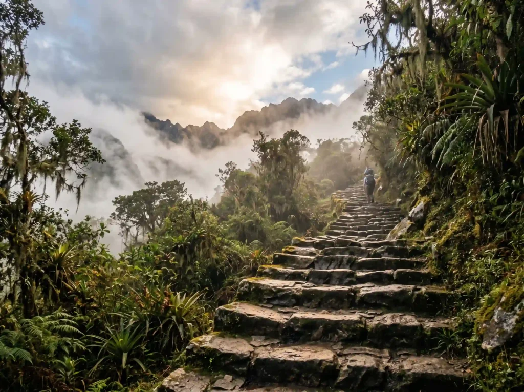
The Classic Inca Trail to Machu Picchu: Four Days Through Cloud Forest and Ancient Ruins
The Inca Trail is the most recognized trekking route in South America. The 43-kilometer path climbs through cloud forest and over high mountain passes. Along the way, it passes a series of genuine Inca ruins. By the morning of day four, you emerge at the Sun Gate above Machu Picchu.
That arrival moment — appearing through the Sun Gate as Machu Picchu materializes below in the morning mist — is why people plan this trip years in advance. It is earned in a way that taking the bus from Aguas Calientes simply is not.
The section of trail most people underestimate is day two. The path climbs to Dead Woman’s Pass at 4,215 meters — the highest point on the entire route. Altitude affects people differently, and no amount of general fitness fully prepares you for that elevation. Spending at least two nights in Cusco, which sits at around 3,400 meters, before you start the trail is not optional. It is the single most important preparation step.
- Distance: Approximately 43 kilometers. A 2-day version covers a shorter section of the trail.
- Duration: 4 days and 3 nights.
- Best time to go: May through September, during the Andean dry season.
The trail is capped at 500 people per day — guides and porters included. The effective number of hikers per day is closer to 200. Permits are only sold through licensed operators, and bookings open for the following year starting in October. For popular dates in peak season, they are often gone within hours of opening.
The trail closes completely every February for maintenance. If you miss the permit window, the Salkantay Trek is a strong alternative. It reaches Machu Picchu by a different route, carries no permit limit, and is — by most accounts — more scenically varied than the classic trail.
Volcanic Terrain and Glacial Wilderness: Iceland, Patagonia, and New Zealand
The next three trails share one defining characteristic: remoteness. Iceland’s volcanic interior, the Patagonian steppe, and New Zealand’s Fiordland are not places people end up by accident. They require commitment to reach, and that commitment is part of what makes them worth it.
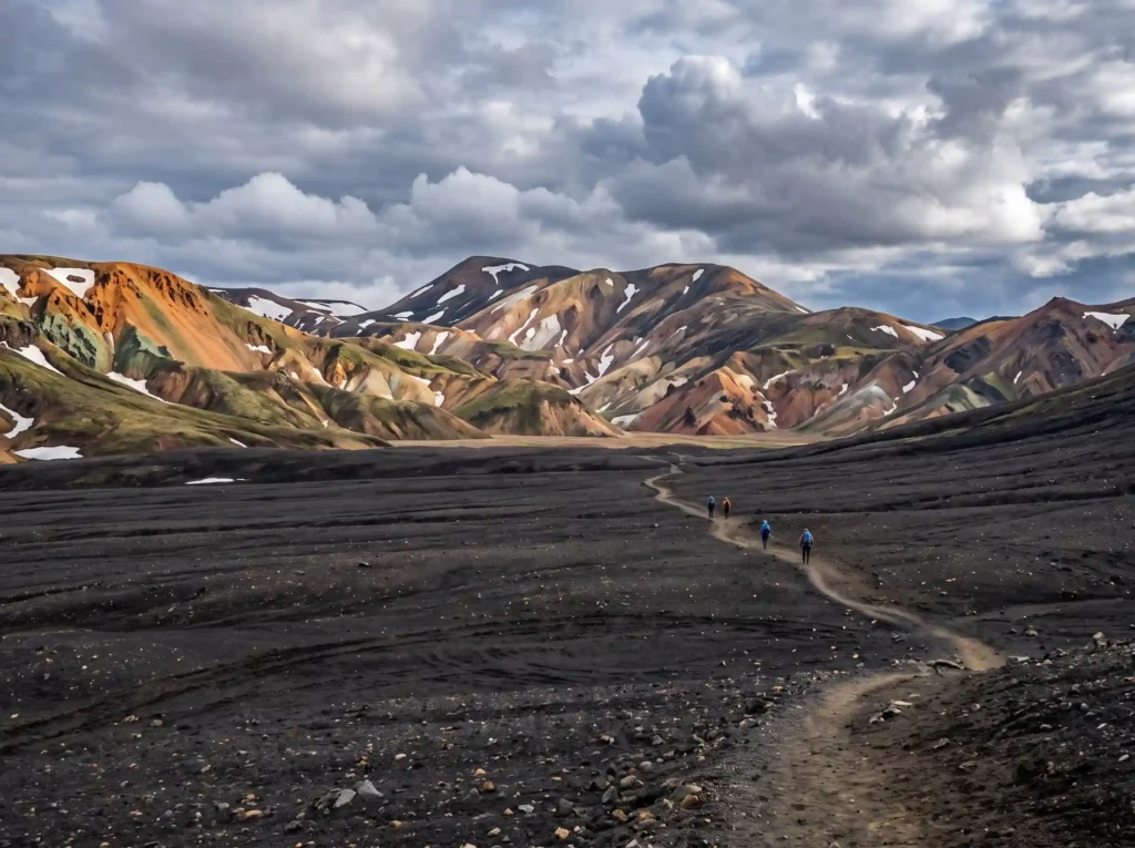
The Laugavegur Trail: 55 Kilometers Through Iceland’s Volcanic Interior
The Laugavegur Trail looks like nowhere else on earth. Over four to five days, you walk through bright purple and red rhyolite mountains, across wide black ash deserts, and past natural hot springs. The landscape shifts so dramatically from one day to the next that it can feel like a different planet each morning.
The trail connects Landmannalaugar in the north to Þórsmörk in the south. Most hikers walk north to south, which involves less cumulative climbing. That direction choice is not just a comfort preference — it makes a real difference in daily effort.
- Distance: Approximately 55 kilometers.
- Duration: 4 to 5 days.
- Best time to go: July and August. The official season runs from late June to early September.
The mountain huts along the route fill up within hours of the booking window opening each year. Tent camping is permitted only at the designated sites near each hut — not on the open trail. If you want a hut spot in peak season, set a reminder for the day booking opens and be ready the moment the system goes live.
Worth knowing: the Laugavegur connects at Þórsmörk with the Fimmvörðuháls Trek. That extension adds roughly 25 kilometers and two more days, ending near Skógar on the south coast. For hikers with the time and stamina, the combined route is one of the most dramatic multi-day walks in Europe.
The W-Trek in Torres del Paine: Patagonia’s Essential Five-Day Route
The W-Trek gets its name from the shape the route traces across the map of Torres del Paine National Park. It links three of the park’s most dramatic landscapes. First, the Torres — the granite towers that give Patagonia its skyline. Then the Valle del Francés and the face of the Grey Glacier.
The weather is the part nobody fully prepares for. Expect sun, rain, hail, and hurricane-force winds — sometimes within the same morning. The wind in particular is relentless on exposed sections near the towers and the glacier. It is not just cold. It is physical.
- Distance: 70 to 85 kilometers, depending on the exact route.
- Duration: 5 days at a comfortable pace. Fit hikers complete it in 3 to 4 days.
- Best time to go: October through April. December to February brings the strongest winds and the largest crowds. March and April offer better weather stability and striking autumn colors.
Refugios and campsites along the W-Trek fill quickly — often fully booked by November for the following summer season. Book as early as the reservation system opens. Plan your layering system carefully too. At any point on the trail, conditions can change within an hour.
If you want the full Torres del Paine experience, the O-Circuit extends the W-Trek into a complete loop of roughly 130 kilometers. It adds the less-visited backside of the massif, requires an extra four to five days, and is noticeably wilder and less crowded than the W.
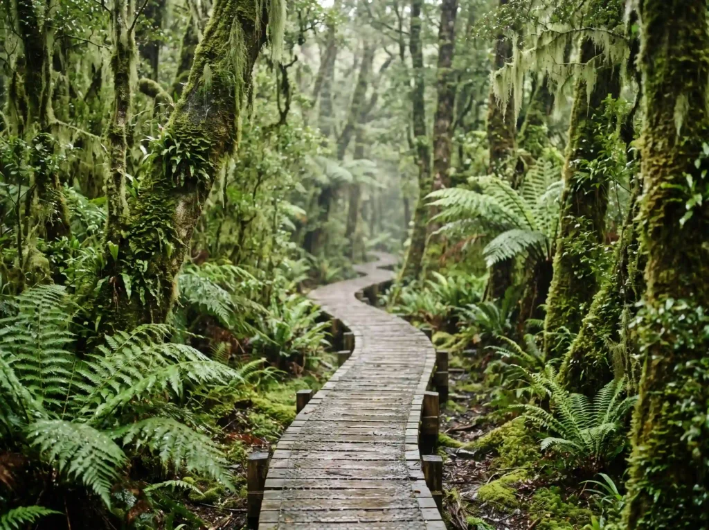
The Milford Track: 53 Kilometers Through Fiordland to Milford Sound
The Milford Track runs through Fiordland National Park on New Zealand’s South Island. It passes through dense temperate rainforest, crosses the alpine Mackinnon Pass, and ends at Sandfly Point on the edge of Milford Sound. Calling it beautiful is accurate but insufficient. It is one of the most varied 53 kilometers you will walk anywhere.
There are two ways to walk the Milford Track. Freedom walkers book Department of Conservation huts and walk independently. Guided walkers book through a private operator and stay in lodge accommodation. Both groups walk the same trail in the same direction — north to south, one-way — but they do not share accommodation. The guided option costs significantly more but is easier to book.
- Distance: Approximately 53 kilometers.
- Duration: 4 days.
- Best time to go: Late October through late April. March and April bring the most stable weather conditions of the season.
Freedom walk hut bookings are released months in advance and sell out within hours — sometimes within minutes — of opening. If you plan to walk in peak season, treat the booking date like an event. Set an alarm and be ready the moment the system goes live.
One practical detail the trail’s reputation does not always prepare you for: Fiordland is one of the rainiest places on earth. Rain here is not an occasional inconvenience. It is part of the trail. Bring genuinely waterproof outer layers — not water-resistant. There is a real difference.
Planning a Major Trek: What Most Hikers Get Wrong
Poor preparation is responsible for more ruined trekking trips than bad weather. Not all of the following apply to every trail on this list, but most apply to at least two.
- Train with a weighted pack: Start at least six weeks before departure. Walking 15 kilometers on flat ground is not the same as carrying 12 kilograms uphill for six hours. Your joints need to learn that difference before the trail does.
- Test your gear before you need it: Never take new boots on a multi-day trail. Blisters on day one can ruin the rest of the trip. The same applies to rain gear — check that it is genuinely waterproof, not just water-resistant.
- Acclimatize for altitude: This applies directly to the Inca Trail, but altitude awareness matters on the TMB and the Laugavegur too. If your route goes above 3,000 meters, plan rest days and watch for early signs of altitude sickness. Headache, nausea, and fatigue are common. They are also warnings.
- Book a licensed local guide where required or relevant: On the Inca Trail, a licensed operator is legally required. On remote routes — the Himalayas, parts of the Andes, or any trail without reliable rescue infrastructure — a guide adds safety and local context. The knowledge a good guide brings is not something a guidebook replaces.
- Follow Leave No Trace principles: Carry out all your waste. Stay on marked trails. Camp only at designated sites. These trails exist because the ecosystems around them have been protected. That protection depends entirely on hikers acting accordingly.
One thing most logistics planning does not cover: these trails are not cheap. Between park entry fees, hut or refugio costs, trailhead transport, and permits, a four-day trail can cost several hundred dollars per person. And that is before the plane ticket. Budget honestly from the start.
What These Five Trails Have in Common
None of them ask little of you. They all require genuine planning, real physical effort, and the willingness to deal with weather that does not cooperate. That is not a warning to discourage you. It is the point.
The trails that demand more tend to give more back. The harder the booking process, the more committed the group of people you will meet on the trail. The more remote the route, the less the outside world intrudes on what you came for.
The hardest part of most of these trips is deciding to actually go. Once that decision is made, the rest — the bookings, the training, the logistics — follows. Start there.
Sources
- Hardloop – Outdoor Gear and Trail Information Portal
- Outdoor Magazin – Gear Reviews and Trekking Reports
- Hikingfex – Hiking and Trekking Tips Worldwide
- Bergwelten – Alpine Lifestyle and Mountain Travel Magazine
- Viel Unterwegs – Independent Travel Blog
- Viventura – South America Travel Specialist
- Travelessence – Australia and New Zealand Travel Expert
Quick Comparison
| Trail | Distance | Duration | Best Time to Go | Location |
|---|---|---|---|---|
| Tour du Mont Blanc | Approx. 170 km | 7 to 11 days | Mid-June to mid-September | Europe (Alps) |
| Classic Inca Trail | Approx. 43 km | 4 days | May to September | South America (Peru) |
| Laugavegur Trail | Approx. 55 km | 4 to 5 days | July and August | Europe (Iceland) |
| W-Trek | 70 to 85 km | 5 days | October to April | South America (Patagonia) |
| Milford Track | Approx. 53 km | 4 days | Late October to late April | New Zealand |
Frequently Asked Questions
What is the best time of year to hike the Tour du Mont Blanc?
The best time to hike the Tour du Mont Blanc is from mid-June through mid-September. During this period, the mountain huts are staffed and open. Hikers should avoid arriving before mid-June, as lingering snow can make high passes dangerous without mountaineering experience.
How far in advance do I need to book mountain huts for the Laugavegur Trail?
You should book mountain huts along the Laugavegur Trail as soon as the reservation window opens each year, which typically happens within hours. Due to extreme popularity in peak season, setting a reminder for the opening day is highly recommended to secure a spot.
Is it possible to hike the classic Inca Trail without a permit or guide?
No, the classic Inca Trail requires a permit and must be booked through a licensed local tour operator. Permits are capped at 500 people per day, including guides and porters, and often sell out within hours of opening for the following year.
What is the main difference between the W-Trek and the O-Circuit in Torres del Paine?
The W-Trek is a 5-day route of 70 to 85 kilometers covering the park’s three main highlights, including the Torres, Valle del Francés, and Grey Glacier. The O-Circuit extends the W-Trek into a complete 130-kilometer loop around the backside of the massif, requiring an extra four to five days and offering a wilder, less crowded experience.
How should hikers prepare for the wet weather on the Milford Track?
Fiordland is one of the rainiest places on earth, so hikers must bring genuinely waterproof outer layers rather than just water-resistant ones. Proper preparation is essential since rain is a consistent part of the trail experience on the Milford Track.
