
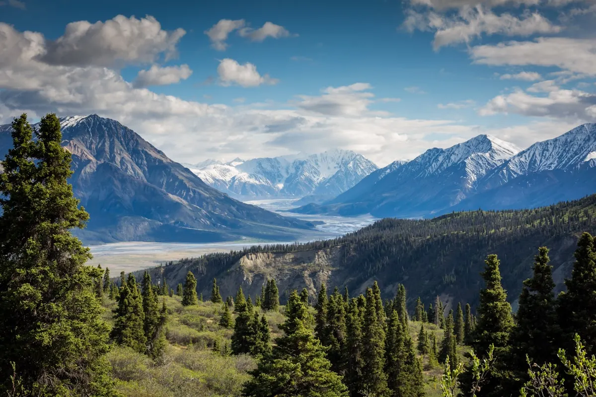
Some trails you hear about once and never forget. These five are exactly those — spanning Nepal, Peru, the Alps, Iceland, and Tasmania, and each demanding a different kind of preparation, a different level of fitness, and a different kind of respect for the terrain. Whether you’re drawn to Himalayan altitude, ancient Incan history, or the raw geological strangeness of Iceland’s interior, one of these 5 long-distance routes belongs on your trekking list.
These aren’t weekend walks. They’re multi-day commitments through wilderness that doesn’t forgive poor planning. That’s also exactly what makes them worth it.
5 Iconic Long-Distance Trails Worth Planning Your Whole Trip Around
Each continent has great hiking. But some routes have built a global reputation that survives decades of word-of-mouth — because the experience genuinely earns it. These are five of them, with the practical details you need to actually plan the trip.
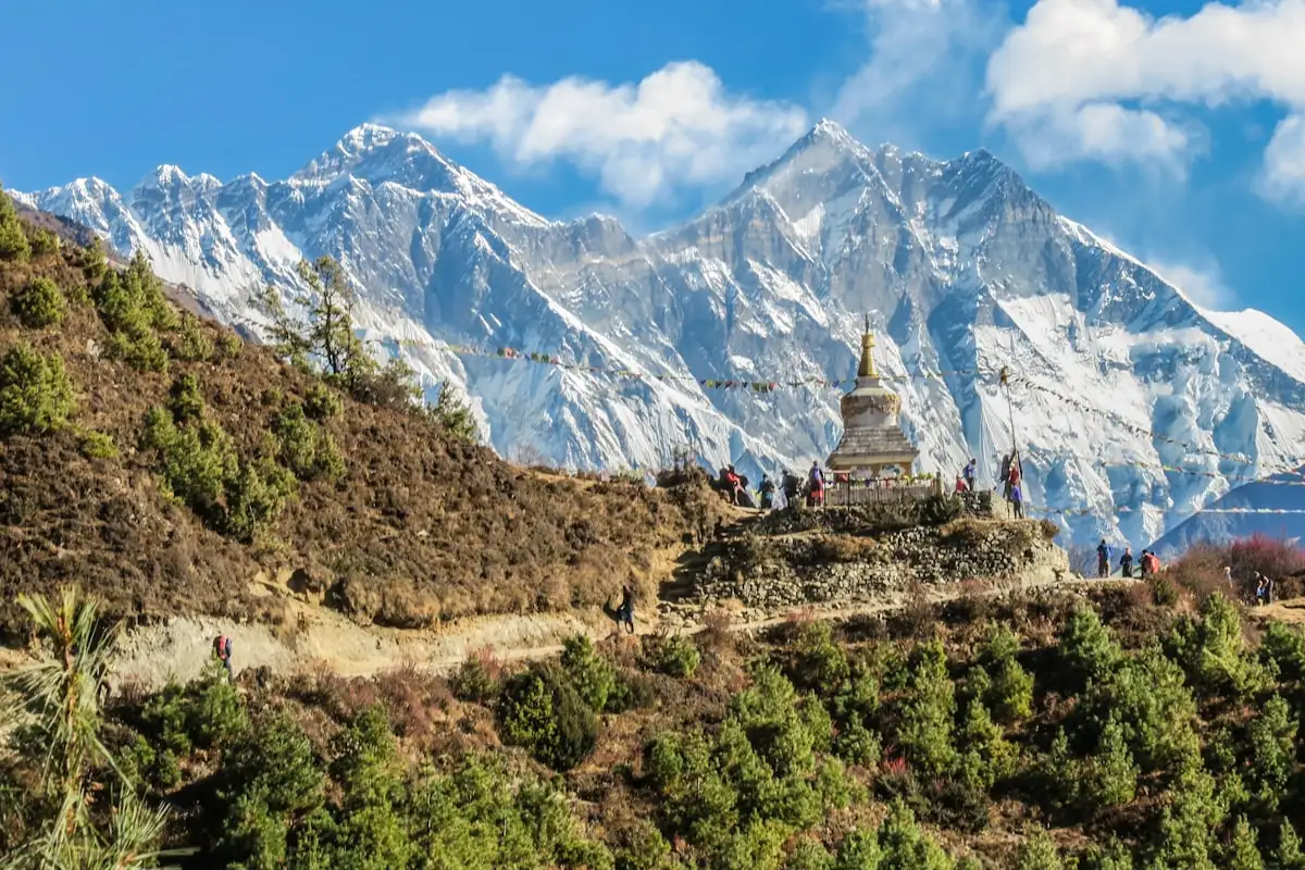
Annapurna Circuit, Nepal: From Subtropical Valleys to the 5,416m Thorong La Pass
The Annapurna Circuit isn’t just a mountain trek. It’s a full landscape progression — you start in humid subtropical river valleys, climb through pine and rhododendron forest, and finish in stark, high-altitude terrain that feels like a completely different country from where you began. That transformation over two weeks is what separates this route from almost everything else in the Himalayas.
- Distance: Approximately 160 to 230 kilometers, depending on route variation and use of local transport for certain sections.
- Duration: Typically 14 to 17 days.
- Highest point: Thorong La Pass at 5,416 meters above sea level.
- Best time to go: Autumn (September to November) for the clearest mountain views; spring (March to May) when the Himalayan hillsides are covered in rhododendron in full bloom.
The Thorong La crossing is the moment the whole circuit builds toward. Most trekkers start well before dawn to summit in the morning before afternoon cloud and wind arrive. At 5,400 meters, the altitude bites even in good weather. The views on a clear day — snow peaks in every direction, the valley falling away below — are the kind you’ll still be describing a decade later.
One thing most English-language guides don’t explain clearly: the NATT routes — the Natural Annapurna Trekking Trails — are a network of marked alternative paths that run parallel to the motor roads now built through parts of the circuit. Walking the main road misses a significant portion of what made this route famous. Where NATT trails exist, use them. The difference in experience is substantial.
Practical tip: Avoid monsoon season (June to August) — landslide risk on this route is real, not a theoretical concern. Deep winter closes Thorong La entirely due to snow accumulation. The shoulder months on either side of the main seasons can work, but require flexibility in your schedule.
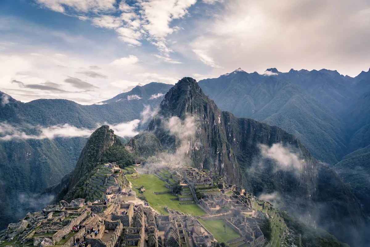
Inca Trail, Peru: 4 Days of Ancient Stone Paths Ending at Machu Picchu
The Inca Trail is the shortest route on this list by a significant margin — 45 kilometers over 4 days. But distance isn’t the metric that matters here. The combination of original Inca paving stones laid hundreds of years ago, cloud forest passages draped in orchids and mist, Andean mountain scenery, and that final arrival at Machu Picchu through the Sun Gate at dawn makes this one of the most emotionally loaded trekking experiences on the planet.
- Distance: Approximately 45 kilometers (classic route).
- Duration: 4 days, 3 nights.
- Best time to go: The dry season, May to September. April, May, September, and October tend to offer greener landscapes and smaller group sizes than peak mid-summer.
The trail follows the actual infrastructure of an empire. Through the cloud forest sections, you walk alongside bromeliads and moss-covered ruins in the mist. Then the vegetation thins, the altitude climbs past 4,200 meters at its highest point, and the architecture becomes more frequent — and more impressive — as you approach the final descent to Machu Picchu.
Here’s what catches most first-timers off guard: permits are capped at 500 people per day total, and they sell out months in advance. You cannot walk this trail independently — a licensed agency is legally required. Book 3 to 6 months ahead, not 3 to 6 weeks. The entire trail also closes in February for maintenance. These are not suggestions — they are regulations enforced at the entry points.
A common mistake is underestimating the altitude. Cusco sits above 3,400 meters, and the trail’s high pass pushes past 4,200 meters. Spend at least a full day or two acclimatizing in Cusco before you start — altitude sickness doesn’t care how fit you are.
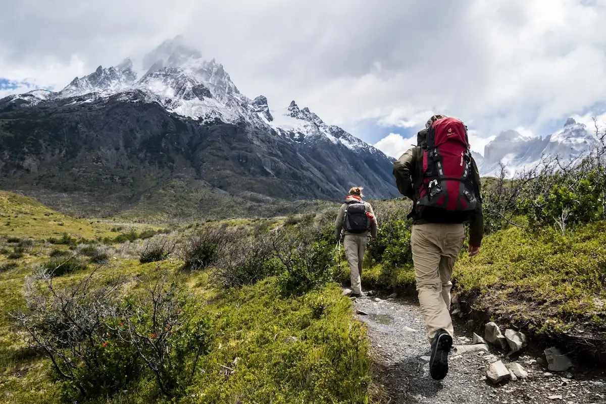
Tour du Mont Blanc: Circumnavigating the Alps Across France, Italy, and Switzerland
The Tour du Mont Blanc — the TMB — is the benchmark against which most European long-distance routes are measured. It circles the entire Mont Blanc massif in a continuous loop through three countries, with mountain hut nights, high alpine passes, and glacier views forming the daily backdrop. At around 165 to 170 kilometers with roughly 10,000 meters of cumulative ascent and descent, this is a serious mountain route — not a long countryside walk.
- Distance: Approximately 165 to 170 kilometers.
- Total elevation gain: Around 10,000 meters of ascent and descent.
- Duration: 8 to 14 days, depending on fitness level and rest days.
- Best time to go: Mid-June to mid-September.
What genuinely sets the TMB apart from most routes on this list is the cultural dimension. In a single week, you eat dinner in a French refuge, wake up to an Italian breakfast, and cross into Switzerland before lunch. The languages shift, the food changes, the architecture of the villages is different — it’s a quietly remarkable thing to experience on foot.
The reality in July and August: the mountain huts fill up weeks in advance. Some of the most popular refuges along the route are fully booked by February. If you arrive at the TMB in peak summer without pre-booked huts, you’re planning to sleep outside. Book early, full stop. September is often a better call — the weather tends to be more stable, the trails are quieter, and the mountain light in autumn is hard to beat.
One practical note for June departures: snow can still cover the higher passes. That’s not a reason to avoid it — but it does mean crampons or micro-spikes in the pack, and the judgment to take a lower variant route when conditions demand it.
Laugavegur Trail, Iceland: Rhyolite Mountains, Lava Fields, and Glaciers in 3–4 Days
There is genuinely nothing else that looks like Iceland’s interior highlands. The Laugavegur Trail covers 55 kilometers through terrain that feels less like Earth and more like something a volcanologist would sketch — multi-colored rhyolite mountains in deep reds, oranges, and greens; steaming sulfur vents cutting through snowfields; vast black lava deserts; and then, without warning, a bright blue glacial river crossing your path that you wade on foot.
- Distance: Approximately 55 kilometers.
- Duration: 3 to 4 days.
- Best time to go: Late June to early September, when the highland huts are open and the passes are snow-free.
This is the shortest route on this list, and arguably the most visually dramatic per kilometer. Every few hours, the landscape changes completely. You move from a barren lava plain to a hillside of obsidian to a geothermal area with boiling mud pools to a river crossing up to your knees in cold glacial melt. The variation keeps it constantly engaging in a way that longer routes sometimes struggle to maintain.
Iceland’s weather is the one variable that nobody can predict and that everyone underestimates. The highlands can shift from clear blue sky to near-whiteout in under an hour. Wind speeds that would be called a storm in most places are just a difficult afternoon in Iceland. Pack for full winter conditions even if you’re going in August — a lightweight waterproof shell is not sufficient.
An option most visitors don’t know exists as a practical route: the Fimmvörðuháls trail, a 25-kilometer extension that continues south from the end of the Laugavegur all the way to Skógar on Iceland’s south coast. Combined, the two trails make a 7-day traverse from the volcanic interior to the sea — one of Iceland’s great lesser-known long walks, and genuinely worth the extra planning.
Overland Track, Tasmania: 65 Kilometers Through Australia’s Most Remote Wilderness
Australia doesn’t immediately come to mind when people name the world’s great trekking routes. That’s a gap the Overland Track corrects quietly — and thoroughly.
Running 65 kilometers through the Cradle Mountain–Lake St. Clair National Park in Tasmania, this is a trail where the remoteness is the whole point. Alpine moorland stretches in every direction. Pencil pine forests follow ancient glacial valleys. The weather shifts constantly, and you carry everything you need from the start — because there is nowhere to resupply and no straightforward way out once you’re in.
- Distance: 65 kilometers.
- Duration: 5 to 6 days.
- Best time to go: December to March — Tasmania’s summer — for the most stable weather conditions.
What separates the Overland Track from most routes on this list is the self-sufficiency it actually requires. There are no teahouses, no villages selling hot noodles, no mountain hut dinners available. You carry your food from start to finish. That changes what the trail tests — it becomes as much about pack planning, weight management, and calorie budgeting as it is about physical fitness on the trail itself.
One rule that surprises many international visitors: during the regulated season (October 1 to May 31), the Overland Track must be walked north to south — Cradle Mountain to Lake St. Clair — with no exceptions. A paid permit is required in advance. Arrive planning to walk the reverse direction and you will be turned back at the entry point. Plan accordingly.
What to Prepare For Before You Set Out on Any of These Trails
Good gear matters. But preparation runs deeper than what’s in your pack.
The most serious physical risk on the Annapurna Circuit and the Inca Trail is altitude sickness — and it doesn’t care how fit you are. It affects people differently every trip, and previous high-altitude experience doesn’t guarantee immunity next time. Acclimatization needs to be a fixed part of your itinerary, not something you squeeze in if you have an extra day. Budget for it before the trail starts.
On European routes — particularly the Tour du Mont Blanc — the underestimated problem is logistics, not terrain. Mountain huts are the only realistic sleeping option on most sections, they have limited capacity, and in high season they fill months in advance. Arriving physically prepared at the end of a 1,200-meter ascent day with no reservation is a bad situation. Sort the huts before you sort anything else.
Weather gear is non-negotiable on every trail on this list. The Laugavegur and the Overland Track in particular can deliver genuinely dangerous conditions with very short warning. A waterproof outer layer, insulation, and dry socks aren’t comfort items — they’re the difference between a hard day and a serious emergency.
If you’re drawn to long-distance trekking more broadly, the routes covered here connect to a much wider world — Patagonia’s Torres del Paine, the Dolomites Alta Via, the Pacific Crest Trail — each a distinct ecosystem and a different kind of challenge that deserves its own preparation entirely.
These five routes reward careful planners and penalize people who assume they’ll work it out along the way. Start with the logistics — especially if permits are involved — and the trail itself will take care of the rest.
Sources
- wikipedia.org
- wetraveltheworld.de
- huttohuthikingeurope.com
- nature-tours.ch
- exploorperu.com
- guidetoiceland.is
- parks.tas.gov.au
Quick Comparison
| Trail | Distance | Duration | Best Time to Go |
|---|---|---|---|
| Annapurna Circuit | 160–230 km | 14–17 days | September–November, March–May |
| Inca Trail | 45 km | 4 days | May–September |
| Tour du Mont Blanc | 165–170 km | 8–14 days | Mid-June–mid-September |
| Laugavegur Trail | 55 km | 3–4 days | Late June–early September |
| Overland Track | 65 km | 5–6 days | December–March |
Frequently Asked Questions
Do I need a permit for the Inca Trail?
Yes, permits are strictly required and capped at 500 people per day. Because you cannot walk the trail independently, you must book your trip through a licensed travel agency 3 to 6 months in advance.
Can you walk the Overland Track in either direction?
During the regulated walking season from October 1 to May 31, walkers are legally required to hike the Overland Track from north to south (Cradle Mountain to Lake St. Clair). A paid permit must be secured in advance to access the route.
How far in advance should I book the Tour du Mont Blanc refuges?
You should book the Tour du Mont Blanc mountain huts several months in advance, especially for the peak summer months of July and August. Many of the most popular refuges along the route are fully booked by February.
What is the best time of year to hike the Annapurna Circuit?
The best months to hike the Annapurna Circuit are in autumn (September to November) for the clearest mountain views, or in spring (March to May) to see the rhododendrons in bloom. You should avoid the summer monsoon season due to high landslide risks.
What are the NATT routes on the Annapurna Circuit?
The NATT (Natural Annapurna Trekking Trails) routes are a system of marked alternative paths designed to bypass the dirt motor roads built through parts of the circuit. They allow trekkers to experience traditional trails and villages away from vehicle traffic.
